Galicia Road Trip: Santiago de Compostela to Baiona, 431 km in 5 Days
A 431 km, five-day drive through north-west Spain: from Santiago de Compostela along the Costa da Morte to Malpica, Muxía, Cape Fisterra and the Ézaro waterfall, then south through Muros, Cambados, A Toxa, the hórreos of Combarro and old Pontevedra to Baiona on the Ría de Vigo.
Rough estimate — fuel + nights at typical rates. Get an exact figure in the calculator.
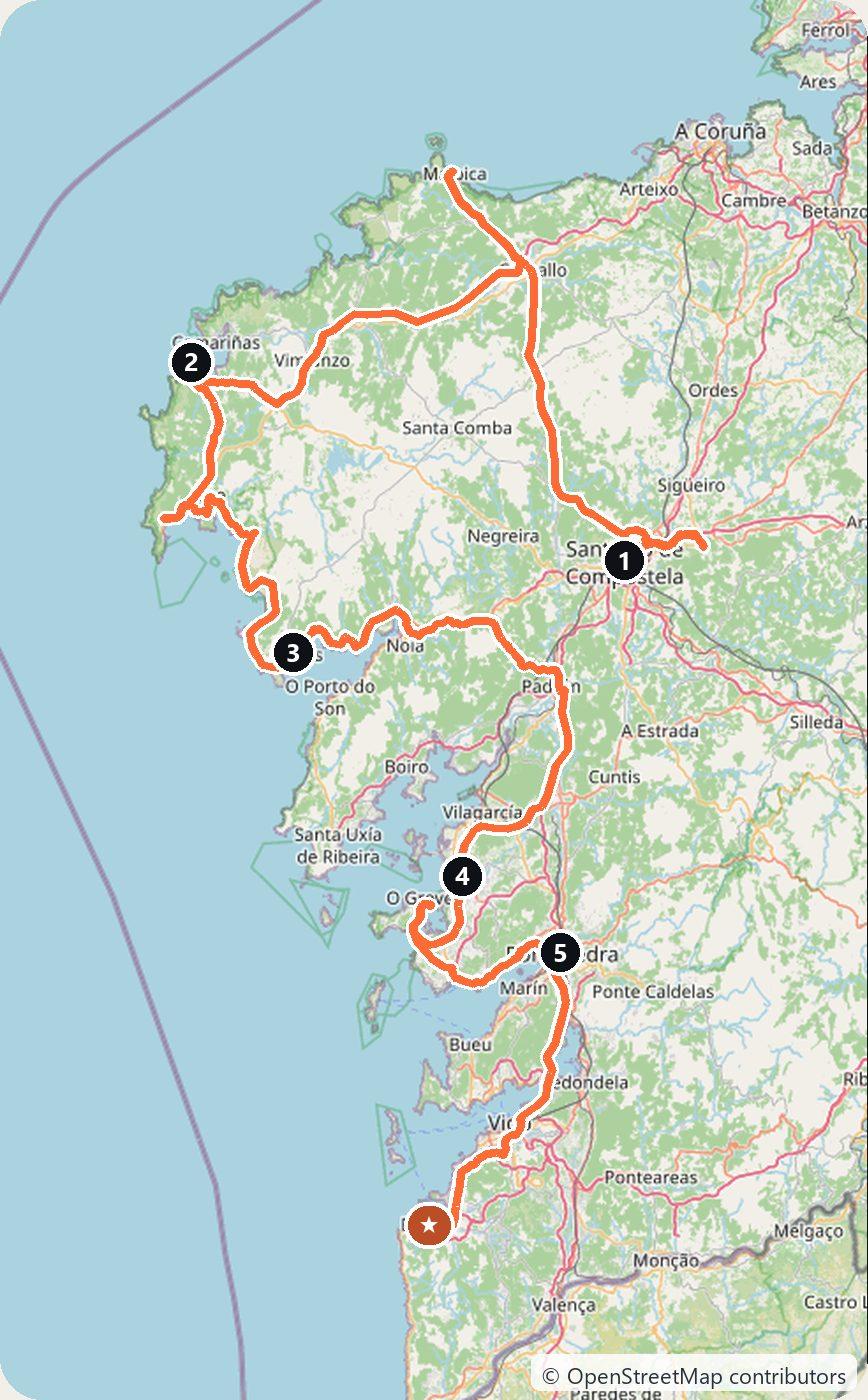
Galicia is the green north-west corner of Spain, just north of Portugal. This five-day drive of about 431 km starts in Santiago de Compostela, whose old town UNESCO declared a World Heritage site in 1985. It first heads west to the Costa da Morte, the “Coast of Death”, which has seen a great many shipwrecks: Malpica, Muxía, the lighthouse on Cape Fisterra and the Ézaro waterfall. Then it turns south into the Rías Baixas, the long sea inlets of the south-west coast, with the old fishing town of Muros, the wine town of Cambados, the island of A Toxa, the granaries of Combarro, the old town of Pontevedra and, at the end, Baiona on the Ría de Vigo. If you want mountains instead of sea, our Picos de Europa route is further east in green Spain.
The order is chosen for the driving. The longest day, out to the wild Costa da Morte, comes first, and the daily distances get shorter as the route moves south. It ends 29 km from Vigo airport, so you do not have to drive back north. Santiago airport is about 132 km from Baiona if you need to return the car there.
Spain drives on the right, and there is no vignette. The main north–south motorway, the AP-9, is a toll road; see the notes on tolls and city driving below.
Day 1 — Santiago de Compostela to Muxía via Malpica (153 km)
Spend your arrival day in Santiago on foot, and pick up the car at Santiago-Rosalía de Castro airport on the morning you leave. The old town is not a place to drive (see below).
Drive north-west to Malpica, a fishing village whose houses cling to the rocks above the harbour. The Sisargas Islands lie just off the coast. They are three islands, Sisarga Grande, Chica and Malata, and they are a special protection area for birds.
Continue west along the Costa da Morte to Muxía. At the tip of the village, facing the Atlantic, is the sanctuary of the Virxe da Barca and the famous “miraculous stones”. A few metres away stands A Ferida (“The Wound”), a sculpture that remembers the Prestige oil spill of 2002. Sleep in Muxía.
Day 2 — Muxía to Muros via Fisterra (91 km)
Drive south to Fisterra and through the town to the cape. The lighthouse stands about 3 km from the town and dates from 1853. All along this coast there are crosses in memory of shipwreck victims.
Then follow the coast east to Ézaro, in Dumbría. Here the river Xallas falls straight into the sea, one of the few rivers in Europe to do so. There is no fixed timetable for the water; the falls are strongest after a wet winter. In summer the falls are lit at night on set dates; check the current schedule before you go.
Continue south along the AC-550 to Muros, and sleep there. The first documents about the town date from the 13th century. Its old town, with arcades, small squares and narrow lanes behind the harbour, was declared a historic-artistic ensemble in 1970.
Day 3 — Muros to Cambados via Noia (82 km)
Before you leave, look into the church of San Pedro de Muros, the old collegiate church of Santa María do Campo. It is built in the “seafaring Gothic” style, and its wooden roof looks like the upturned hull of a ship. You can climb its Baroque bell tower for views over the town and the ría.
Drive along the ría to Noia, at its head, and on south around the Ría de Arousa to Cambados, the home town of Albariño white wine. In the old quarter is the Pazo de Fefiñáns, a manor house on a large square, which is one of the starting points of the Rías Baixas Wine Route. At the foot of A Pastora hill are the 16th-century ruins of Santa Mariña de Dozo, with an old cemetery. The town’s Albariño festival takes place in late July and early August. Sleep in Cambados.
Day 4 — Cambados to Pontevedra via Combarro (55 km)
Drive west to A Toxa, a small island next to O Grove reached by a bridge. It is known for its hot springs and spas. Its small chapel, which dates from the 12th century, was rebuilt and covered on the outside with scallop shells.
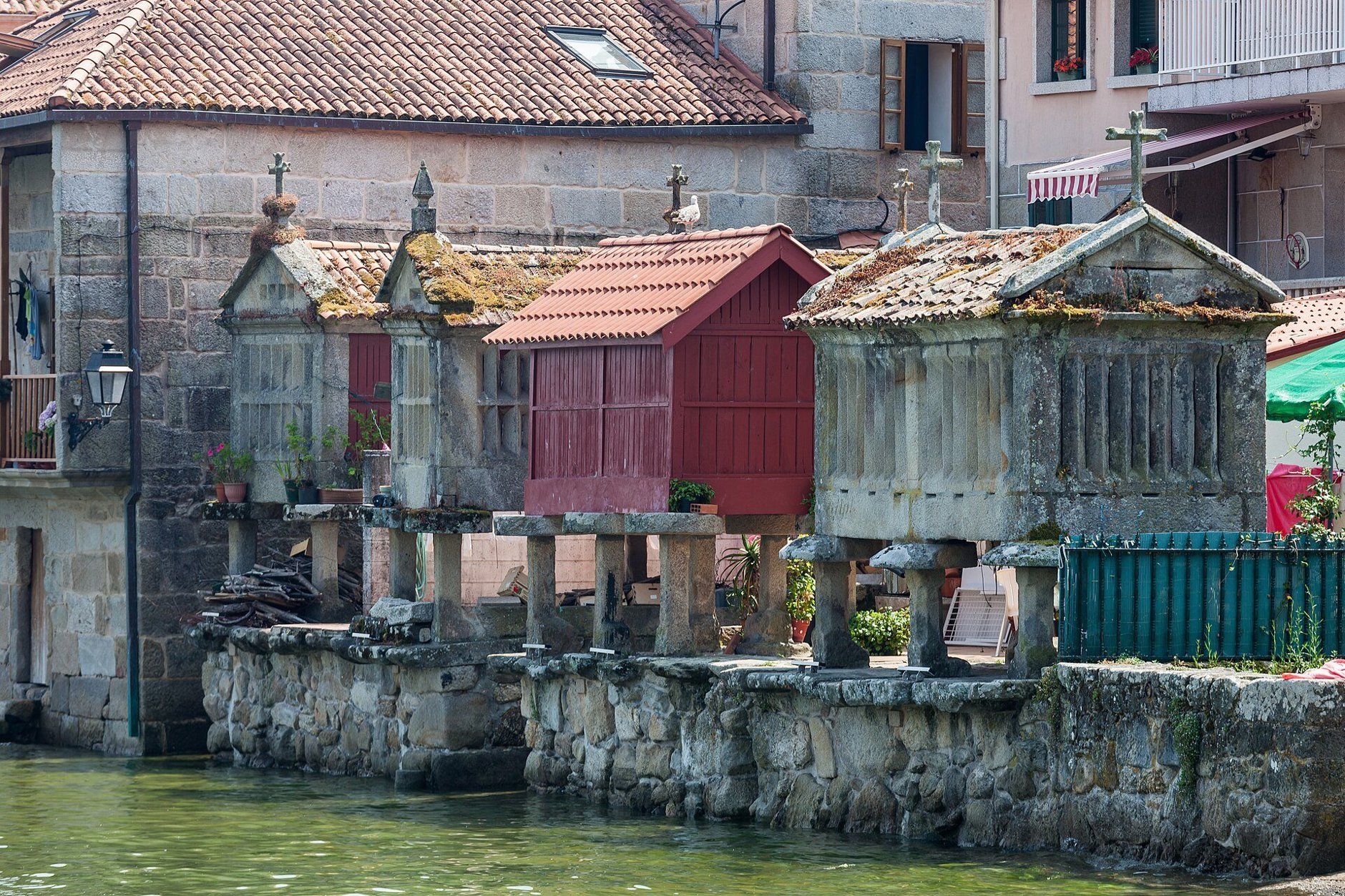
Then drive east to Combarro, on the Ría de Pontevedra. It has more than 30 hórreos, the stone granaries raised on pillars, and most of them stand right by the sea, next to stone crosses and fishermen’s houses. Combarro is a few kilometres from Pontevedra, so you can also see it in the evening light from there.
Sleep in Pontevedra, and leave the car outside the centre (see below). In the old town is the church of the Peregrina, built at the end of the 18th century with a floor plan shaped like a scallop shell. Praza da Leña is a small square with granite houses, arcades, galleries and a stone cross.
Day 5 — Pontevedra to Baiona via Vigo (50 km)
Take the AP-9 south to Vigo (this stretch is tolled; see below) and follow the coast to Baiona. On 1 March 1493 the caravel Pinta, under Martín Alonso Pinzón, sailed into Baiona, and so Baiona was the first town in Europe to hear that America had been found. A replica of the Pinta, built in 1993–94, is moored in the harbour and open to visitors.
Above the harbour is the fortress of Monterreal. It covers 18 hectares, and inside it a Parador hotel opened in 1966. A path of about 3 km runs around it, so you can walk it without staying at the Parador.
Optional: Monte Santa Trega in A Guarda is 32 km south of Baiona. On top, at 341 m, are the remains of a Celtic hill fort that had about 5,000 people at its peak in the first century BC, with a view over the mouth of the river Miño and the coast of Portugal.
The Cíes Islands
The Cíes Islands off Vigo are part of the Atlantic Islands of Galicia National Park, declared in 2002 together with Ons, Sálvora and Cortegada. There are no roads to them, only passenger ferries, from Vigo, Cangas, Baiona, Sanxenxo and Portonovo. In Holy Week and from 15 May to 15 September, the park limits the number of day visitors, and you need an authorisation from the Xunta de Galicia before you buy a ferry ticket. You get it online at autorizacionillasatlanticas.xunta.gal, and in summer the islands are often full, so apply early. Outside those dates you book directly with the ferry companies; check their timetables before you plan a visit out of season. A Cíes day trip fits best as an extra day at the end in Baiona or Vigo.
Add-on: Praia das Catedrais
The Praia das Catedrais (“Beach of the Cathedrals”) is far from this route, on the north coast at Ribadeo in Lugo province, near Asturias. Its rock arches can only be walked under at low tide. In Holy Week and from 1 July to 30 September you need a free online authorisation from the Xunta to go down onto the beach. It is a better fit for a trip that combines Galicia with Asturias.
Tolls, cities and parking
Tolls. The AP-9 from A Coruña through Santiago and Pontevedra to Vigo is still a toll road in 2026, run by the company Audasa. A law of July 2026 transfers the motorway to the Galician government, the Xunta, but the handover only takes effect once both governments sign a transfer agreement, and until then Audasa keeps collecting. You can pay in cash (euros) or by card. Card works at every booth except lanes reserved for the electronic tag, Vía-T. The AP-9 discounts, such as a free return trip within 24 hours, only work with a Vía-T tag, so in a hire car without one you pay the full price both ways. On this route you only need the AP-9 on Day 5, from Pontevedra to Vigo. On Day 1 the fastest route also uses a short stretch of the AG-55 towards Carballo, a toll motorway run by the Xunta, which has frozen its tolls for 2026.
Santiago de Compostela. The old town, the Cidade Histórica, is closed to cars without a permit, and the city now treats it as its low emission zone. Access does not depend on your car’s environmental label: you need an authorisation, which is meant for residents, businesses and garage owners. Bollards guard most entrances and number-plate cameras watch the rest. If your hotel is inside, ask it how to arrive before you go. Otherwise leave the car in one of the 20 public car parks that the city’s tourist office lists, such as Praza de Galicia or Belvís, or in the free parking area at Santa Marta, and walk.
A Coruña. The route does not go through A Coruña, but if you start there: the “ZBE Centro”, which covers the old town, Avenida da Mariña, Paseo do Parrote and some streets of Pescadería, is open only to public transport, taxis and authorised vehicles, with loading from 6:00 to 11:00. You may not park inside it, and entering without permission is a serious offence with a €200 fine. Hotel guests may drive in to drop off people and luggage.
Pontevedra. The city has built its centre around walking. Only necessary traffic may drive in, such as deliveries, emergency services and cars going to a garage. The speed limit is 30 km/h on all city streets and 10 km/h in the historic centre, and you enter and leave the old town by the same point, so you cannot drive across it. The city has about 3,500 free parking spaces on its outer ring, about 10 minutes’ walk from the centre, plus paid underground car parks.
Vigo. Vigo’s city council gave final approval to a low emission zone ordinance in July 2026, with four zones (Centro, Praza de Portugal, Bouzas and Calvario), restrictions that start with cars that have no DGT environmental label, and fines of up to €200. The start date of enforcement and the rules for foreign cars were not yet clear when we checked, so look at the Concello de Vigo website before you drive into the centre.
When to go
Bring a rain jacket in any season. Summer is when the Cíes visitor limits, the Catedrais bookings and the Ézaro night lighting all apply, and when the islands fill up, so plan and book ahead. In winter the coast is quiet and the Ézaro falls carry the most water after heavy rain, but the days are short, and the Cíes ferries are not something to count on: check the operators first.
Costs
Use the cost calculator to price fuel and nights for your dates. Budget for accommodation, fuel for about 431 km, car hire, and AP-9 tolls if you use the motorway. Add the Cíes ferry if you go to the islands. The Catedrais booking is free. In summer, book rooms on the coast and the Cíes ferry early.
This trip is also in the free Roadcut trip planner: change the number of days and where you sleep each night, pick your vehicle to see the fuel cost, check the weather on the road, and open each day in Google Maps, Apple Maps or Waze.
Where to stay on this route
Night by night, in the towns this itinerary sleeps in.
- Night 1Hotels in Muxía →
- Night 2Hotels in Muros →
- Night 3Hotels in Cambados →
- Night 4Hotels in Pontevedra →
- Night 5Hotels in Baiona →
The search opens with sample dates a month from today — change them to yours on Booking. Affiliate link — we may earn a commission at no extra cost to you.
Get this itinerary by email
The days and the nights in your inbox, with a link back here when you are ready to book.
We use your address only to send this itinerary, unless you tick the box. Privacy
⚡ By electric car on this route
79 charging stations within 1.5 km of the road, 55 of them fast (DC). Most powerful: 250 kW.
Longest stretch without a fast charger tagged: 77 km, from km 209 of the route.
According to OpenStreetMap and operators’ websites. Fast = a DC plug or 50 kW and more; not every station has its power filled in, so there may be more. Power and stations missing from OpenStreetMap also from DGT / MITERD — nap.dgt.es (CC BY). See them on the planner map → · EV charging →
🚦 Know before you go
Tolls · Ferries · Good to know
Tolls. Spain has no vignette. The AP-9 motorway (A Coruña–Santiago–Pontevedra–Vigo) is still tolled in 2026 and run by Audasa until its transfer to the Xunta takes effect; pay by cash or card, but its discounts only work with a Vía-T tag, so a hire car pays full price. This route only needs it from Pontevedra to Vigo on Day 5. The fastest road on Day 1 uses a short stretch of the AG-55, a Xunta toll motorway whose tolls are frozen for 2026. The coast roads are free.
Ferries. Optional: passenger ferries to the Cíes Islands sail from Vigo, Cangas, Baiona, Sanxenxo and Portonovo. In Holy Week and from 15 May to 15 September you need an authorisation from the Xunta de Galicia (autorizacionillasatlanticas.xunta.gal) before you buy the ferry ticket.
Good to know. Do not drive into Santiago's old town: it is closed to cars without a permit and watched by bollards and cameras, so use a public car park such as Praza de Galicia or Belvís, or the free area at Santa Marta. Pontevedra's centre is for necessary traffic only (10 km/h in the old town); park free on the outer ring, about 10 minutes' walk away. Vigo approved a low-emission zone in July 2026; check the Concello de Vigo website for the start date before driving into the centre.
Estimate your exact costs in the cost calculator. Prices are approximate — check official sites before you travel. Some links are affiliate links.
Plan this trip
Where to sleep
Hotels & B&Bs →Holiday homes & apartments →Campsites (bookable) →Campervan & overnight spots →Tours & tickets
Find things to do →Affiliate link — we may earn a commission at no extra cost to you.
Drive on from here
New road trips in your inbox
One email when we publish a new European route — the full guide, map and real costs. No spam, unsubscribe anytime.