Valencia to Alicante Road Trip: the Costa Blanca in 4 Days
A 293 km one-way drive from Valencia to Alicante: L'Albufera and El Palmar, the capes and coves of Dénia and Xàbia, the Penyal d'Ifac in Calp, an inland detour to Guadalest and the Algar falls, then Altea and Villajoyosa — with the booking rule for the Ifac summit and the traffic zones to avoid.
Rough estimate — fuel + nights at typical rates. Get an exact figure in the calculator.
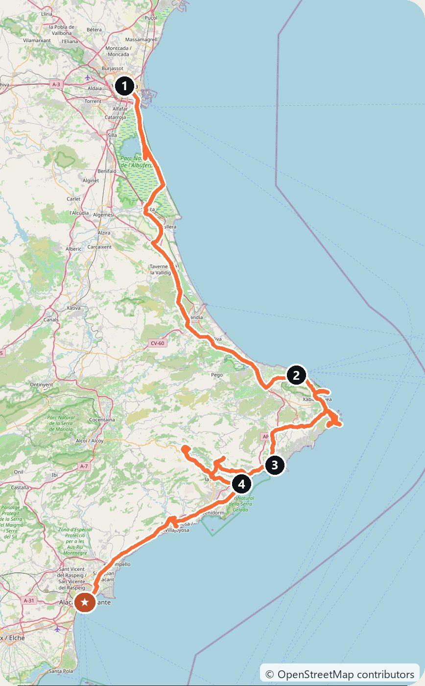
This trip drives from Valencia to Alicante in four days. It follows the coast south through the rice fields of L’Albufera, then around the capes of the Marina Alta, where the mountains meet the sea. It climbs inland once, to the castle village of Guadalest, and ends on the palm promenade of Alicante. The drive is about 293 km, one way.
You drive on the right, and the route has no tolls. The AP-7 motorway between Tarragona and Alicante has been free since 1 January 2020, after 48 years of tolls. In December 2025 the government also made the AP-7 bypass around Alicante permanently free. Pick up the car in Valencia and return it in Alicante. A one-way rental can cost extra, so check the drop-off fee when you book.
Check the traffic rules in the cities before you go. Valencia has no low-emission zone in force: the city council rejected the final ordinance on 28 October 2025, and no new text had been voted by October 2026. Valencia’s old town is a different matter. The northern part, Ciutat Vella Nord, is a residential priority area, and only vehicles with an authorisation may drive in. Hotels and public car parks inside it are among those that can request access, so ask your hotel before you drive in, or park outside the area. Benidorm fines any car that enters its low-emission zone without a permit, and the old town of Alicante is open only to residents and authorised vehicles (details on Day 4).
The route also works in winter. Most sights stay open all year, but some keep shorter winter hours.
Day 1 — Valencia to Dénia (112 km)
Start in Valencia. In October 1957 the river Turia flooded large parts of the city. Afterwards it was moved south around the city, a project called the Plan Sur that was finished in 1969. The old riverbed became the Turia Gardens, 9 km of park through the middle of the city. At its south-east end stands the City of Arts and Sciences, designed by Santiago Calatrava, with the Oceanogràfic by Félix Candela. The first building, the Hemisfèric, opened in 1998. In the old town, see the Llotja de la Seda, the silk exchange built between 1482 and 1533 and a UNESCO World Heritage Site since 1996.
Drive 10 km south to L’Albufera natural park. Its lake is Spain’s largest freshwater lake, and rice is still grown around it. Traditional Albufera boats take visitors out on the water for about 40 minutes. Most of them leave from the Gola de Pujol jetty. Evening trips are the most popular because of the sunsets, so book ahead. Then drive on to El Palmar, a village with many restaurants and a fish market. Valencia’s tourist board says paella was invented by the farmers of this area. The floods of October 2024 hit the park hard. By October 2025 the Generalitat had removed about 300,000 tonnes of debris from the park and the towns around it, and had committed €100 million to its recovery. It also said that essential work still remained.
Continue south to Dénia. The town sits below the Montgó, a mountain of 753 m that has been a natural park since 1987. Above the centre stands the Castell de Dénia, an Islamic fortress whose first walls date from the 11th and 12th centuries. In October 2026 the town’s tourism website listed the castle as temporarily closed, with no reopening date, so check before you climb up. Sleep in Dénia.
Day 2 — Dénia to Calp (60 km)
This is a short day of capes, coves and viewpoints. Drive up to the lighthouse on Cap de Sant Antoni. The sea below it is a marine reserve. The windmills on the cape mark the start of Xàbia’s viewpoint route, which links 15 viewpoints between Cap de Sant Antoni and Cap de la Nau.
Drop down into Xàbia (Jávea in Spanish). Its old town has stately houses, chapels, small squares and the 16th-century church of Sant Bartomeu. Then follow the road out to the lighthouse on Cap de la Nau. Nearby, a road leads down to the Granadella cove, where the woods come almost to the water. In summer, Xàbia closes the road with a barrier when the small car park is full. In 2025 the control started on 14 June, parking cost €9 a day, and a tourist train carried visitors down.
Continue south to Moraira. Its coastal fort, the Castell de Moraira, stands beside L’Ampolla beach. It was built in the 18th century to defend the coast against Berber pirates and restored in the early 1980s. Inside is a small exhibition on the sea, watchtowers and piracy.
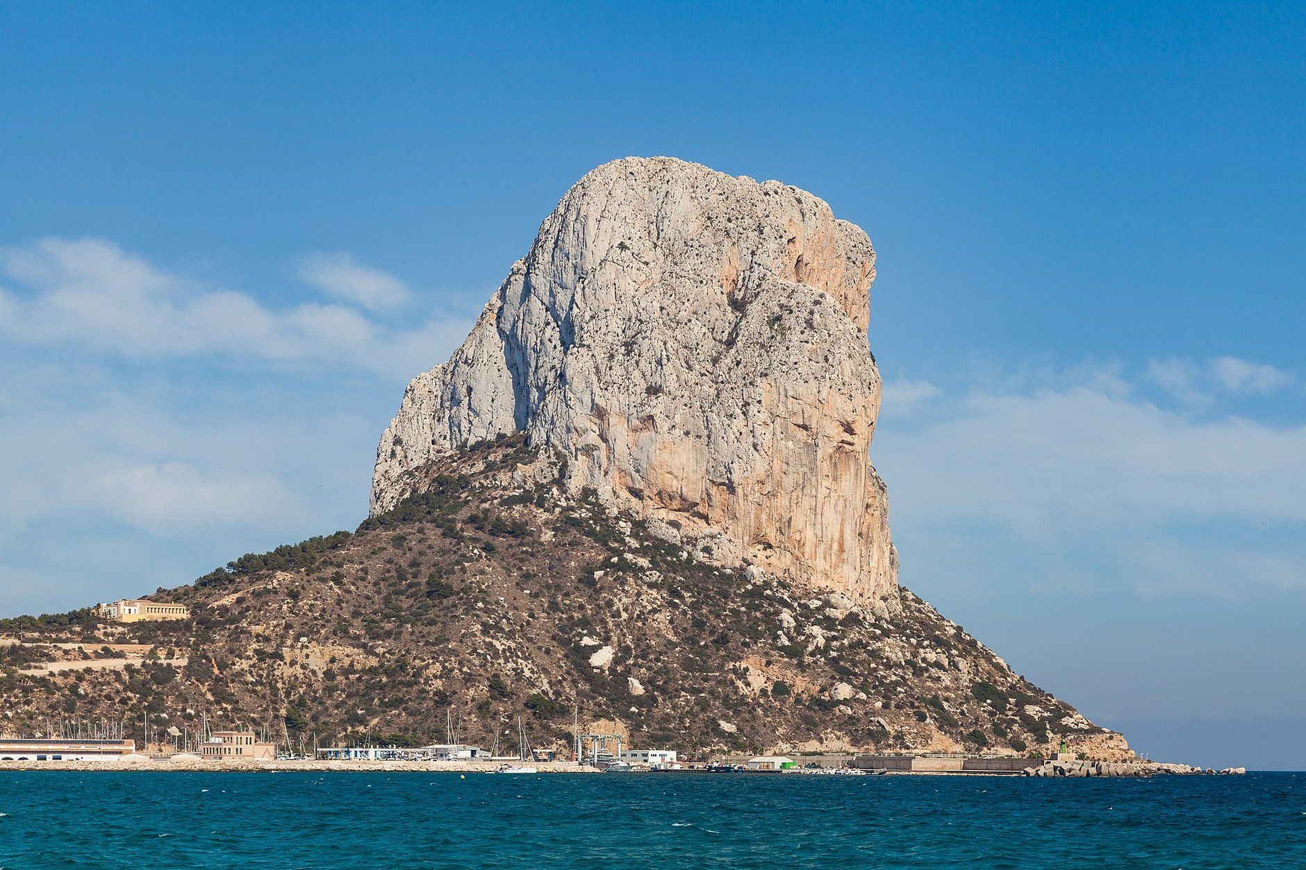
End the day in Calp, under the Penyal d’Ifac. This rock rises 332 m from the sea, and it has been a natural park since 1987. The path to the summit starts at the visitor centre and passes through a tunnel cut into the rock. The last stretch is steep, with ropes fixed to the rock. To walk this path, the Ruta Roja, you must book in advance. The park allows 300 visitors a day. Bookings are made online only, from 9 days before up to the same day, while places last. They are personal, and park agents may ask to see them. The park advises against taking children beyond the tunnel. Bring mountain shoes and water. Sleep in Calp.
Day 3 — Calp to Altea via Guadalest (62 km)
Today you leave the coast for the mountains. First drive to Fonts de l’Algar, near Callosa d’en Sarrià. Here the river Algar falls in a chain of waterfalls and pools, and you may swim in them. Lifeguards are on duty only at Easter and in summer. In 2026 the site is open every day except 1 and 6 January and 24, 25 and 31 December. It opens at 9:00 and closes at 17:30 from 19 October to 30 November and in March, at 15:30 from December to February, and at 20:00 in July and August. In the low season (16 October to 14 June) adults pay €6. You must buy online tickets at least 24 hours ahead, or buy them at the ticket office on the day while places last. There is free parking next to the tourist office, about 700 m from the entrance.
Then climb west to Guadalest. The old village sits on a rock above the valley. Its castle, known as Sant Josep, was built by the Muslims in the 11th century. An earthquake on 22 June 1644 partly destroyed it, and in 1708, during the War of the Spanish Succession, a mine blew up part of it. From the top you look down on the Guadalest reservoir. You can drive down to walk around the reservoir and over its dam. The village also has several small museums. The tourist office is in the car park on Avenida Alicante.
Drive back down to the coast at Altea. Its old town is a maze of white façades, old walls and viewpoints. At its heart is the church of Nuestra Señora del Consuelo, with its dome of blue and white tiles. Sleep in Altea.
Day 4 — Altea to Alicante (59 km)
South of Altea the road passes Benidorm. You can skip it. If you do go in, know the rule first: any vehicle that enters its low-emission zone (the centre and the Levante and Poniente seafronts) needs a permit. Without one, the fine is €200, or €100 if you pay early. Cars that park in a public car park inside the zone are registered by the car park, so that is the easy way in.
Stop instead at Villajoyosa. Its old seafront is a row of houses painted in bright colours. The town is also known for its chocolate industry, and the old chocolate makers here run factory museums.
The last stretch brings you to Alicante. Above the city, on Mount Benacantil (166 m), stands the Castell de Santa Bàrbara. Its origins go back to the 9th century. The quickest way up is a lift inside the mountain. It starts opposite Postiguet beach, on Avenida Juan Bautista Lafora, and costs €2.70. The castle and the lift open at 10:00. They close at 18:00 from 15 November to 27 February, at 20:00 in spring and autumn, and at 23:00 from 17 June to 4 September. The last entry is 40 minutes before closing. Below the castle, walk the Explanada de España, the seafront promenade paved with a wave mosaic of red, cream and black marble under rows of palms. The old town is open to cars only for residents and authorised vehicles, so leave the car in a car park outside it. Return the car in Alicante.
Costs
Use the cost calculator to price fuel and nights for your dates. There are no tolls and no vignettes on this route. Budget for accommodation, fuel for about 293 km, car rental and the one-way drop-off fee from Valencia to Alicante, plus parking in the cities. Entry fees on the way are small: €6 for an adult at Fonts de l’Algar in the low season, €2.70 for the lift to the Alicante castle, and €3 for the Dénia castle when it reopens. At the Granadella cove in Xàbia, summer parking cost €9 a day in 2025. The summit path on the Penyal d’Ifac needs a booking, so make it as soon as you know your Calp day.
This trip is also in the free Roadcut trip planner: change the number of days and where you sleep each night, pick your vehicle to see the fuel cost, check the weather on the road, and open each day in Google Maps, Apple Maps or Waze.
Where to stay on this route
Night by night, in the towns this itinerary sleeps in.
- Night 1Hotels in Dénia →
- Night 2Hotels in Calp →
- Night 3Hotels in Altea →
The search opens with sample dates a month from today — change them to yours on Booking. Affiliate link — we may earn a commission at no extra cost to you.
Get this itinerary by email
The days and the nights in your inbox, with a link back here when you are ready to book.
We use your address only to send this itinerary, unless you tick the box. Privacy
⚡ By electric car on this route
161 charging stations within 1.5 km of the road, 84 of them fast (DC). Most powerful: 350 kW.
Longest stretch without a fast charger tagged: 27 km, from km 184 of the route.
According to OpenStreetMap and operators’ websites. Fast = a DC plug or 50 kW and more; not every station has its power filled in, so there may be more. Power and stations missing from OpenStreetMap also from DGT / MITERD — nap.dgt.es (CC BY). See them on the planner map → · EV charging →
🚦 Know before you go
Tolls · Good to know
Tolls. Spain has no vignette and nothing on this route is tolled. The AP-7 between Tarragona and Alicante has been free since 1 January 2020, after 48 years of tolls, and in December 2025 the government made the AP-7 bypass around Alicante permanently free as well. The N-332 coast road and the mountain roads to Guadalest and Fonts de l'Algar are free.
Good to know. Valencia has no low-emission zone in force (the council rejected the ordinance in October 2025), but its old town, Ciutat Vella Nord, is a residential priority area open only to authorised vehicles; ask your hotel or park outside. Benidorm fines any car that enters its low-emission zone (centre, Levante and Poniente) without a permit: €200, or €100 if paid early; parking in a public car park inside the zone registers you. Alicante's old town is for residents and authorised vehicles only. The Penyal d'Ifac summit path in Calp needs an online booking (300 visitors a day, bookable from 9 days ahead). In summer Xàbia closes the road to Granadella cove with a barrier when the car park is full. A one-way rental from Valencia to Alicante can carry a drop-off fee.
Estimate your exact costs in the cost calculator. Prices are approximate — check official sites before you travel. Some links are affiliate links.
Plan this trip
Where to sleep
Hotels & B&Bs →Holiday homes & apartments →Campsites (bookable) →Campervan & overnight spots →Tours & tickets
Find things to do →Affiliate link — we may earn a commission at no extra cost to you.
New road trips in your inbox
One email when we publish a new European route — the full guide, map and real costs. No spam, unsubscribe anytime.