La Palma Road Trip: 285 km Round the Island from Santa Cruz in 3 Days
A 285 km loop from Santa Cruz de La Palma in three days: up the LP-4 to Roque de los Muchachos and the observatory on the rim of the Caldera de Taburiente, La Cumbrecita, the 2021 Tajogaite volcano and Puerto Naos, the volcanoes and salt pans of Fuencaliente, and the laurel forest of Los Tilos.
Rough estimate — fuel + nights at typical rates. Get an exact figure in the calculator.
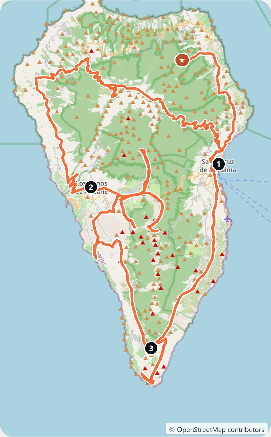
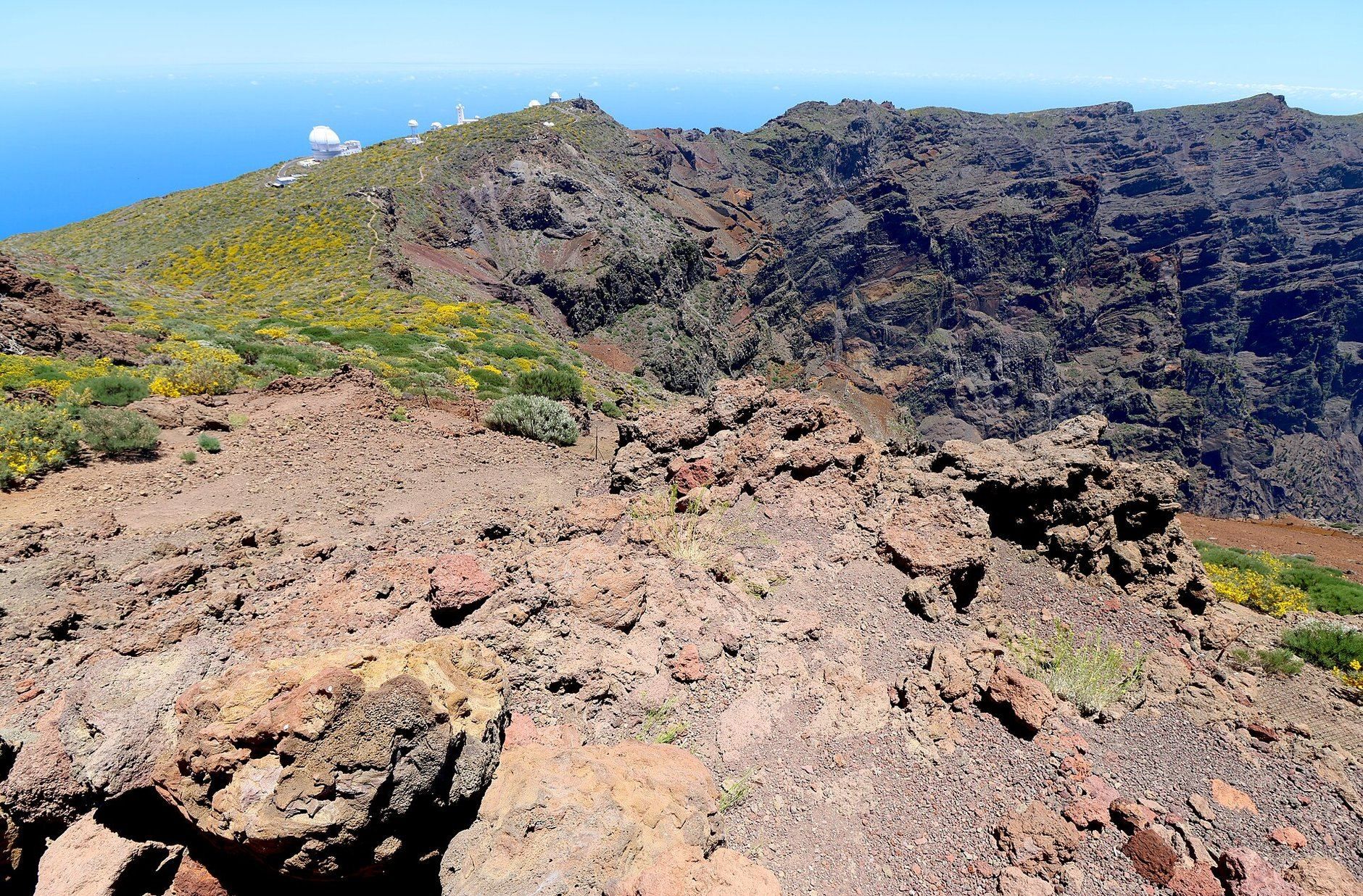
La Palma is the steep green island at the north-western edge of the Canaries. Its centre is the Caldera de Taburiente, a crater-like basin about 10 km across and a national park since 1954. On its rim stand the white domes of an international observatory. The south is a ridge of young volcanoes, and in 2021 one of them, Tajogaite, erupted for 85 days. This loop starts in Santa Cruz de La Palma and takes three days and about 285 km. It climbs from the sea to Roque de los Muchachos, the highest point of the island, crosses to the Aridane valley in the west, looks into the caldera from La Cumbrecita, passes the new volcano on its way south to Fuencaliente, and comes back up the east coast. It is a year-round drive, and winter is a good time for it, as long as you keep an eye on the weather on the summit road.
The Canary Islands are part of Spain, so you drive on the right, and there are no toll roads on La Palma. Most people pick up the car at La Palma Airport (SPC), about 8 km south of Santa Cruz. Three things to know before you go. Driving up to the La Cumbrecita viewpoint between 8:30 and 16:00 needs a free parking booking, and there are only 20 spaces. You cannot walk to the Tajogaite cone on your own: it is visited only on guided tours. And the access to Los Tilos was closed again after rockfalls in October 2026, so check it before Day 3.
Day 1 — Santa Cruz de La Palma to Los Llanos de Aridane via Roque de los Muchachos (101 km)
Leave Santa Cruz on the LP-4, the road that climbs from the edge of the capital towards the summit of the island; the last few kilometres up to the top are on the LP-403. It is about 43 km of bends, and it takes close to an hour without stops.
At the top is Roque de los Muchachos, at 2,426 m the highest point of La Palma. A short path leads from the car park to the rocks and the viewpoint on the rim of the Caldera de Taburiente. Along the ridge stand the telescopes of the Roque de los Muchachos Observatory, run by the Instituto de Astrofísica de Canarias. You cannot walk around the observatory on your own. Guided visits run in small groups, in daytime only, take about an hour and a half and must be booked on the website of the Fundación Starlight. After dark the summit is left to the astronomers. The island’s official tourism site says you can still drive the LP-4 up to its junction with the LP-403 at night, and asks you to switch off your headlights and torches when you stop to look at the stars.
The summit road closes in bad weather. In January 2026 the Cabildo de La Palma closed the LP-4 because of ice on the road and small rockfalls, and snow and ice are a risk on the summit all winter. Check the Cabildo’s road updates on the morning you go.
Continue over the top and down the north-west side of the LP-4 to the LP-1, then turn south to Puntagorda. Keep going south on the LP-1 through Tijarafe to the Mirador El Time, a watchtower on the road between Puntagorda and Los Llanos. From it you look down on the Aridane valley, the deep Barranco de las Angustias, which comes out of the caldera, and the harbour of Puerto de Tazacorte at its mouth.
Drop down to Los Llanos de Aridane and sleep there.
Day 2 — Los Llanos de Aridane to Fuencaliente (84 km)
Drive up to the Caldera de Taburiente visitor centre just east of El Paso, which opens every day from 9:00 to 18:00. From here a 7 km road climbs to La Cumbrecita, a pass on the south-eastern rim of the caldera, with a viewpoint into the basin and short paths along the edge.
Book before you go. Between 8:30 and 16:00 you need a free parking permit for La Cumbrecita, booked on reservasparquesnacionales.es or in person at the visitor centre. The car park has 20 spaces. You can book from a month ahead up to the same day, in slots of at least 30 minutes, and you show the booking on your phone at the barrier at El Riachuelo. Arrive more than 20 minutes late and the guard will not let you through. Miss a booking without cancelling by midnight the day before, or stay longer than booked, and you cannot book again for a year. After 16:00 you can drive up without a booking. Dogs are not allowed in the park. The park can close the road for safety, and the Cumbrecita road, the LP-302, was closed in bad weather in October 2026.
Then head south to the new volcano. Tajogaite opened on the ridge of Cumbre Vieja on 19 September 2021. Its visible activity ended on 13 December, after 85 days, and the eruption was declared over on 25 December 2021. Its lava flowed through the Aridane valley down to the sea. The cone itself can only be visited on a guided walk run by a company authorised by the Cabildo, on a trail of about 5 km there and back; most of the walks start from Llano del Jable on the LP-301. Do not go off on your own: the cone is still not stable, and fines for entering the closed zone start at €600. Llano del Jable also has one of the island’s astronomical viewpoints, at 1,345 m.
Drive down across the lava field to Puerto Naos on the west coast. Volcanic gases kept the resort closed from the eruption until July 2024. Today its beach is open again, together with the largest hotel, the supermarket and some of the beach restaurants, and by May 2026 more than 1,200 homes and businesses in Puerto Naos and La Bombilla had been allowed to reopen. More than 1,500 sensors watch the gas levels. The worst-affected part of town, the “zona negra”, was still closed in the latest report we found, so obey the signs. A new coast road, 3.9 km long and built over the lava, has linked Puerto Naos with Tazacorte since May 2023.
From Puerto Naos, take the LP-2 south to Fuencaliente, the village near the southern tip of the island, and sleep there.
Day 3 — Fuencaliente to Santa Cruz de La Palma via Los Tilos (100 km)
Start at the San Antonio Volcano visitor centre on the edge of Fuencaliente. A path runs along the rim of the crater (about 30 minutes there and back), and the exhibition covers the eruption of the neighbouring Teneguía volcano, which erupted for 23 days from 26 October to 18 November 1971. From October to June the centre is open from 9:00 to 17:00, in July, August and September from 10:00 to 19:00.
Wind down to the coast at the southern tip of the island, where the Salinas de Fuencaliente salt pans lie next to the old and new lighthouses. The lava of 1971 flowed towards the coast here but missed the lighthouse and the salt pans.
Drive back up and take the LP-2 north along the east coast to Santa Cruz de La Palma. Its historic quarter is a protected Historic-Artistic Site. Walk the cobbled Calle Real to the Plaza de España, with the town hall and the Church of El Salvador, and along the Avenida Marítima, where the old houses have carved wooden balconies hung with flowers. The Naval Museum stands at one end of the Plaza de la Alameda.
Then drive north on the LP-1 and the LP-105, about 25 km, to Los Tilos, in San Andrés y Sauces. This ravine of laurel forest, kept alive by the trade-wind cloud, is the core of the La Palma Biosphere Reserve: UNESCO first listed it as the Los Tiles reserve in 1983 and extended it in 2002. After a big rockfall in December 2023, the access road reopened on 12 April 2025 with a new protective tunnel, 15 parking spaces before it, and the waterfall open from 10:00 to 18:00. On 2 October 2026, after new rockfalls, the Cabildo closed the usual accesses to Los Tilos and the Cubo de La Galga again, and cut the LP-105 at the entrance to the information centre. We found no reopening date. Check the Cabildo de La Palma’s updates before you drive up, and turn back if the road is closed.
Return to Santa Cruz (about 27 km). If you drop the car at the airport instead, the day is about 106 km.
Costs
Use the cost calculator to price fuel and nights for your dates. There are no tolls or vignettes anywhere on La Palma. Budget for accommodation, fuel for about 285 km (the LP-4 alone climbs from sea level to almost 2,400 m), car rental, the San Antonio Volcano visitor centre (€8 for adults who do not live in the Canary Islands, free under 12), a guided walk to the Tajogaite cone, and an observatory tour if you want one. The La Cumbrecita parking permit is free. Winter is high season for northern Europeans, so book the car early.
The weather is the one thing to plan around. Mountain roads close after storms, rockfalls and, on the summit, snow and ice. Up at Roque de los Muchachos it can be freezing while the coast is warm, so pack a warm layer.
This trip is also in the free Roadcut trip planner: change the number of days and where you sleep each night, pick your vehicle to see the fuel cost, check the weather on the road, and open each day in Google Maps, Apple Maps or Waze.
Where to stay on this route
Night by night, in the towns this itinerary sleeps in.
The search opens with sample dates a month from today — change them to yours on Booking. Affiliate link — we may earn a commission at no extra cost to you.
Get this itinerary by email
The days and the nights in your inbox, with a link back here when you are ready to book.
We use your address only to send this itinerary, unless you tick the box. Privacy
⚡ By electric car on this route
24 charging stations within 1.5 km of the road.
For most of them OpenStreetMap does not record the power, so we cannot say where the fast chargers are — check your charging app before you set off.
According to OpenStreetMap and operators’ websites. Fast = a DC plug or 50 kW and more; not every station has its power filled in, so there may be more. Power and stations missing from OpenStreetMap also from DGT / MITERD — nap.dgt.es (CC BY). See them on the planner map → · EV charging →
🚦 Know before you go
Tolls · Good to know
Tolls. Spain has no vignette and there are no toll roads on La Palma, so every LP road on this loop is free.
Good to know. Driving up to the La Cumbrecita viewpoint between 8:30 and 16:00 needs a free parking permit from reservasparquesnacionales.es or the Caldera de Taburiente visitor centre: 20 spaces, bookable from a month ahead to the same day in slots of at least 30 minutes; arrive more than 20 minutes late and you are turned back, and a no-show bars you from booking for a year. After 16:00 access is free. The Tajogaite cone can only be visited on a guided walk with a company authorised by the Cabildo. The LP-4 to Roque de los Muchachos closes for ice, snow and rockfalls in winter (it was closed in January 2026), and the Cabildo closed the usual access to Los Tilos after rockfalls on 2 October 2026, so check the Cabildo de La Palma's road updates before you drive up.
Estimate your exact costs in the cost calculator. Prices are approximate — check official sites before you travel. Some links are affiliate links.
Plan this trip
Where to sleep
Hotels & B&Bs →Holiday homes & apartments →Campsites (bookable) →Campervan & overnight spots →Tours & tickets
Find things to do →Affiliate link — we may earn a commission at no extra cost to you.
Drive on from here
New road trips in your inbox
One email when we publish a new European route — the full guide, map and real costs. No spam, unsubscribe anytime.