La Gomera Road Trip: 169 km Round the Island from San Sebastián in 3 Days
A 169 km loop from San Sebastián de La Gomera in three days: over the laurel forest of Garajonay National Park past Roque de Agando to Valle Gran Rey, along the north to the glass floor of the Mirador de Abrante, Agulo and Hermigua, and back via Playa de Santiago.
Rough estimate — fuel + nights at typical rates. Get an exact figure in the calculator.
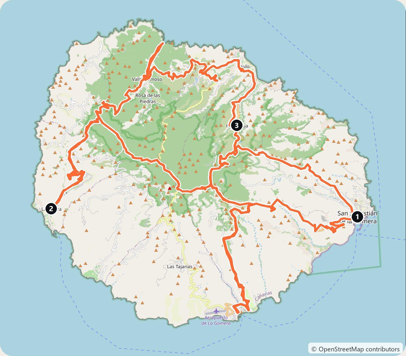
La Gomera is the small island just west of Tenerife. Its high centre is covered by Garajonay National Park, declared in 1981 and a UNESCO World Heritage Site since 1986. Its 3,984 hectares hold more than half of the mature laurel forest left in the Canary Islands. This loop starts and ends at the ferry port of San Sebastián de La Gomera and takes three days and about 169 km. It crosses the park on the GM-2 to Valle Gran Rey in the west, follows the GM-1 along the north through Vallehermoso, Agulo and Hermigua, and comes back by way of Playa de Santiago in the south. The distances are short, but the roads are almost all bends, so plan on slow driving. The island’s tourist board gives an average temperature of 22 °C all year, and winter is a good time to go.
The Canary Islands are part of Spain, so you drive on the right, and there are no toll roads on La Gomera. Most visitors arrive by ferry from Los Cristianos in the south of Tenerife to San Sebastián. The crossing takes about 50 minutes. Two companies run it: Fred. Olsen Express, with up to five departures a day, and Baleària, which took over the Canary Islands routes of Naviera Armas on 18 May 2026 and runs them as Baleària Canarias, with up to four a day. La Gomera also has a small airport near Playa de Santiago, but it only has flights from the other islands.
You can take a Tenerife hire car on the ferry, and Fred. Olsen lets you book it before you know the plate. But the rental company also has to allow the car to leave Tenerife: some do, and others ask for authorisation first. The simpler plan, and the one this route follows, is to cross as a foot passenger and pick up a car on La Gomera. CICAR, for example, has offices in the harbour of San Sebastián and at the airport.
Day 1 — San Sebastián de La Gomera to Valle Gran Rey (49 km)
Start with a short walk in San Sebastián de La Gomera. In the town stands the Torre del Conde, a 15th-century Castilian fortress.
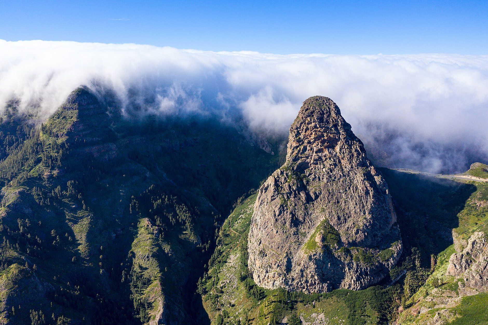
Then take the GM-2, which climbs from the capital into the centre of the island. After about 19 km you reach the Mirador de los Roques, a viewpoint at 1,115 m at the entrance to Garajonay. From here you see five rock towers. The best known is Roque de Agando, an old volcanic chimney about 180 m high, with its summit at 1,246 m. Next to the road is the monument to the victims of the 1984 wildfire, in which 20 people died and more than 900 hectares burned.
Fire is part of the park’s story. In August 2012 another wildfire burned about 3,600 hectares of the island, including 742 hectares of Garajonay, about 20% of the park.
Continue west on the GM-2 to Pajarito, about 4 km further. From here a path climbs to the Alto de Garajonay, at 1,487 m the highest point of La Gomera; the island’s tourist board lists the Pajarito – Alto – Pajarito walk at 4.6 km. On clear days the summit has a wide view over the island’s valleys and the Atlantic.
Four kilometres on is La Laguna Grande, the largest recreation area in the park, with a restaurant, picnic tables, toilets, a park information point and a 900 m path through the forest. About 5.5 km further, on the same road, is Raso de la Bruma. A short circular trail here (1.3 km, about 40 minutes) goes through one of the wettest laurel forests in the park, which is often in the trade-wind cloud even in summer.
Shortly after, the GM-2 meets the GM-1. Turn south on the GM-1 to the Mirador César Manrique at Palmarejo, a viewpoint designed by the Lanzarote artist César Manrique, high above the gorge of Valle Gran Rey with its palm groves and terraced fields. Then drive down the valley to Valle Gran Rey and sleep there. La Calera is the largest of its villages.
Day 2 — Valle Gran Rey to Hermigua (60 km)
Drive back up the GM-1 past Arure and follow it north to Vallehermoso. Its municipality has nearly 27 km of coast. On the north-west coast of Vallehermoso is Los Órganos, a cliff of basalt columns about 200 m wide and 80 m high. It is a natural monument, and you can only reach it by sea. Boat trips run from Valle Gran Rey and Playa de Santiago. If you want to go, book one for the morning before you leave Valle Gran Rey.
From Vallehermoso the GM-1 runs east. Before Agulo, turn up the CV-5 to the Garajonay visitor centre at Juego de Bolas, in La Palmita. It is open every day, including holidays, from 9:30 to 16:30, and it has exhibitions, gardens and a café.
About 2 km on from the visitor centre, at the end of the road, is the Mirador de Abrante. It stands at 620 m on the edge of a cliff, and at the far end a 7 m overhang with a glass floor sticks out over the drop. The village of Agulo lies 400 m below, and Tenerife is on the horizon on a clear day.
Drive back down to the GM-1 and into Agulo, founded in 1607. Its old quarter of narrow cobbled streets and white houses with red tile roofs lies in the lower part of the village, near the coast.
Continue on the GM-1 to Hermigua, a valley where bananas and vines are still the main source of income. At the coast is the Pescante de Hermigua, an old loading pier and crane finished in 1908. It was used until the late 1950s, when the port of San Sebastián took over. Sleep in Hermigua.
Day 3 — Hermigua to San Sebastián de La Gomera via Playa de Santiago (60 km)
Leave Hermigua on the CV-14, the El Rejo road, which climbs about 7 km from the valley up to the GM-2 on the ridge. This road has had emergency slope works since April 2026, and the Cabildo de La Gomera closed it on the morning of 13 October 2026 to lift in a crane. It was also closed in January 2026 to clear rockfall after the storm Francis. If it is closed, go back to San Sebastián on the GM-1 and take the GM-2 west from there.
On the ridge, turn east on the GM-2 for about 4 km and then south on the GM-3, which runs down for 14 km to Playa de Santiago. The village has a beach of almost half a kilometre, next to a small fishing port, and restaurants around it. This is the other departure point for boat trips along the coast.
Take the GM-3 back up and the GM-2 east to San Sebastián de La Gomera, about 30 km, and return the car at the harbour before the ferry.
Costs
Use the cost calculator to price fuel and nights for your dates. There are no tolls or vignettes on La Gomera. Budget for accommodation, fuel for about 169 km of mountain roads (the GM-2 climbs from sea level to over 1,100 m in 19 km), car hire on the island, and the ferry from Los Cristianos and back. Add a boat trip if you want to see Los Órganos. The services at the Garajonay visitor centre are free. Winter is high season for northern Europeans, so book the ferry and the car early.
The weather is the one thing to plan around. The centre of the island is often in cloud while the coast is sunny, and after storms the Cabildo closes mountain roads. Check the Cabildo de La Gomera’s road updates before each day’s drive.
This trip is also in the free Roadcut trip planner: change the number of days and where you sleep each night, pick your vehicle to see the fuel cost, check the weather on the road, and open each day in Google Maps, Apple Maps or Waze.
Where to stay on this route
Night by night, in the towns this itinerary sleeps in.
- Night 1Hotels in Valle Gran Rey →
- Night 2Hotels in Hermigua →
The search opens with sample dates a month from today — change them to yours on Booking. Affiliate link — we may earn a commission at no extra cost to you.
Get this itinerary by email
The days and the nights in your inbox, with a link back here when you are ready to book.
We use your address only to send this itinerary, unless you tick the box. Privacy
⚡ By electric car on this route
13 charging stations within 1.5 km of the road, 9 of them fast (DC). Most powerful: 90 kW.
Longest stretch without a fast charger tagged: 22 km, from km 71 of the route.
According to OpenStreetMap and operators’ websites. Fast = a DC plug or 50 kW and more; not every station has its power filled in, so there may be more. Power and stations missing from OpenStreetMap also from DGT / MITERD — nap.dgt.es (CC BY). See them on the planner map → · EV charging →
🚦 Know before you go
Tolls · Ferries · Good to know
Tolls. Spain has no vignette and there are no toll roads on La Gomera, so every GM and CV road on this loop is free.
Ferries. La Gomera is reached by ferry from Los Cristianos in the south of Tenerife to San Sebastián de La Gomera, about 50 minutes. Fred. Olsen Express runs up to five crossings a day and Baleària (Baleària Canarias, formerly Naviera Armas) up to four. The simplest plan is to cross as a foot passenger and hire the car on La Gomera; if you take a Tenerife hire car across, the rental company must allow it to leave Tenerife.
Good to know. The island's roads are short but almost all bends: the GM-2 climbs from San Sebastián to 1,115 m at the Mirador de los Roques in about 19 km. The CV-14 El Rejo road out of Hermigua has had emergency slope works since April 2026 and was closed on the morning of 13 October 2026 and in January 2026 after the storm Francis; if it is shut, use the GM-1 back to San Sebastián. Los Órganos can only be seen from the sea, on boat trips from Valle Gran Rey or Playa de Santiago. Check the Cabildo de La Gomera's road updates before each day's drive.
Estimate your exact costs in the cost calculator. Prices are approximate — check official sites before you travel. Some links are affiliate links.
Plan this trip
Where to sleep
Hotels & B&Bs →Holiday homes & apartments →Campsites (bookable) →Campervan & overnight spots →Tours & tickets
Find things to do →Affiliate link — we may earn a commission at no extra cost to you.
Drive on from here
New road trips in your inbox
One email when we publish a new European route — the full guide, map and real costs. No spam, unsubscribe anytime.