Gran Canaria Road Trip: 255 km Round the Island from Las Palmas in 3 Days
A 255 km loop from Las Palmas in three days: Teror, Pico de las Nieves and Roque Nublo, Tejeda and the cave village of Artenara, Agaete and the GC-200 down the west coast, Puerto de Mogán and the Maspalomas dunes.
Rough estimate — fuel + nights at typical rates. Get an exact figure in the calculator.
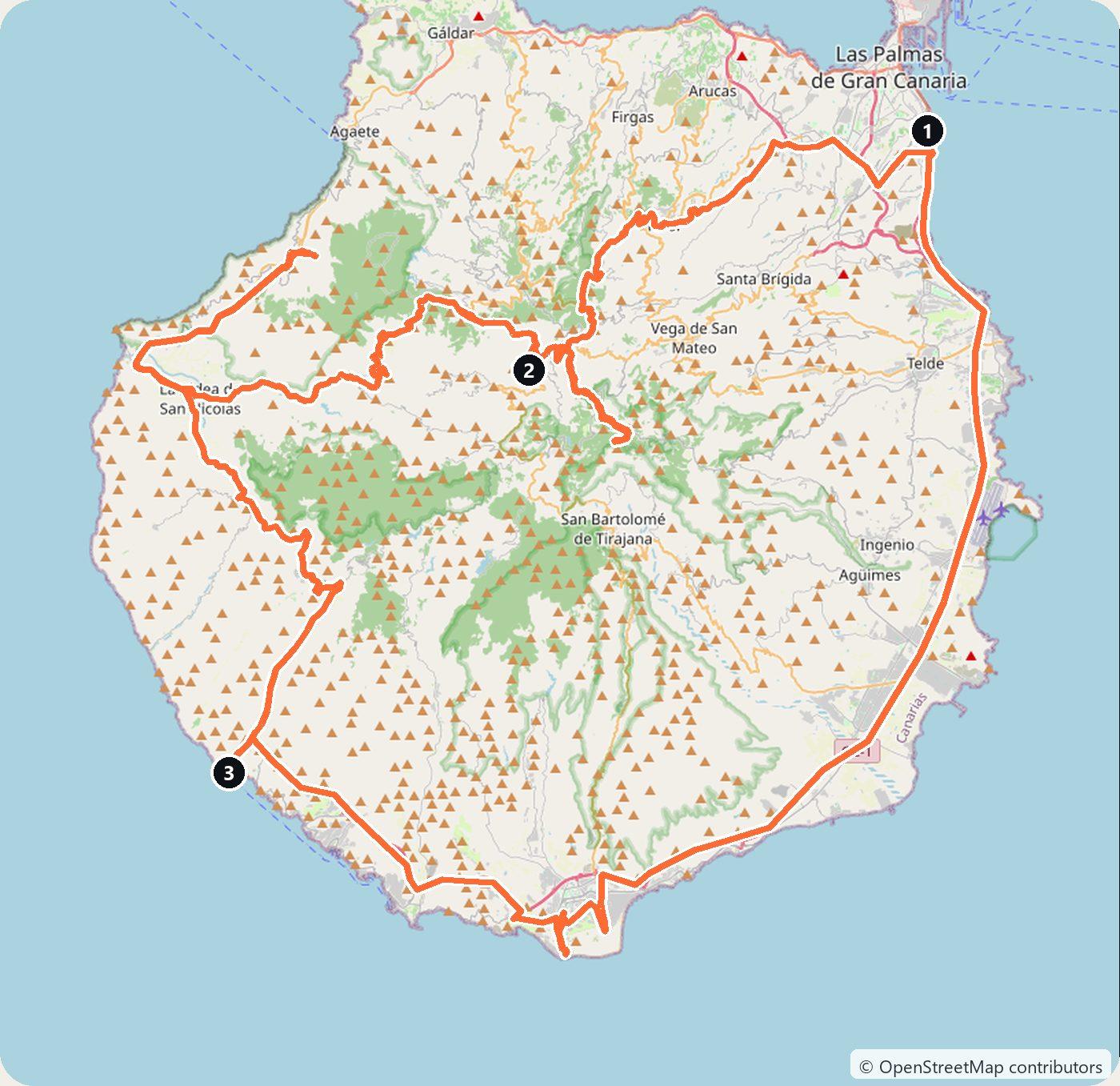
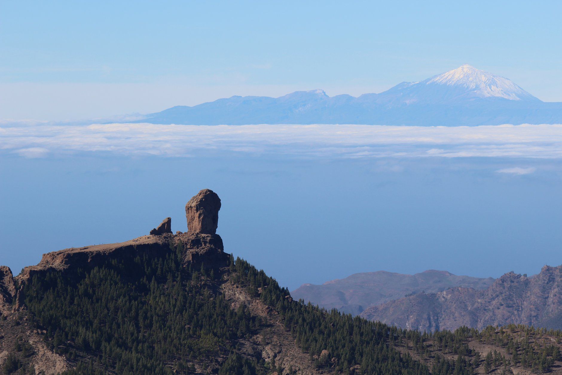
Most people who fly to Gran Canaria never leave the beaches of the south. That is a pity, because the island is round and steep, and the road from the coast to its centre climbs almost 2,000 m. Up there are pine forest, cave villages and the basalt monolith of Roque Nublo. On a clear day you can see Teide on Tenerife, rising above the clouds. This loop starts in Las Palmas and takes three days and about 255 km. It crosses the mountains first, drops to Agaete on the north-west coast, follows the GC-200 down the wild west side to Puerto de Mogán, and comes back along the south coast past the Maspalomas dunes. The island lies off the coast of Africa, so this is a year-round drive. Winter is the best time for it, because the light is clear and the south is warm while northern Europe is grey.
The Canary Islands are part of Spain, so you drive on the right. There are no tolls: the GC-1 and GC-2 motorways are free. Most people pick up the car at Gran Canaria Airport (LPA), about 21 km south of the city. Two things to know before you go. You cannot park at Roque Nublo any more, and walking up to the rock between 10:00 and 17:00 needs a free booking, so plan Day 1 around it. And the old cliff road between Agaete and La Aldea has been closed since 2016. You still drive the GC-200 down the west coast, but on a new road with tunnels, and rockfalls after heavy rain can close it for a day or more.
Day 1 — Las Palmas to Tejeda (67 km)
Start in Vegueta, the old quarter of Las Palmas, then take the GC-21 inland to Teror. Its basilica of Nuestra Señora del Pino holds the Virgin of the Pine, patron of the Diocese of the Canary Islands. On Sundays a market of local food and crafts fills the square beside it.
Keep climbing through the pines to Pico de las Nieves. The viewpoint, with a car park next to it, stands at about 1,950 m, near the highest point of the island. From it you look down into the Tejeda basin, across to Roque Nublo and, above the sea of cloud, to Teide on Tenerife. It is cold up here even when the coast is warm. The official tourism site advises warm clothes above 1,400 m.
Then comes Roque Nublo, a basalt monolith more than 70 m high and the best-known sight in the mountains. The car park at Degollada de La Goleta, where the trail starts, is closed to visitors’ cars. Leave the car at Cruz de los Llanos, a few minutes away, and take the line 18 shuttle bus to the trail (about 10 minutes). The bus runs every 30 minutes from 9:30 to 18:00 and charges the normal Global bus fare. You can also walk from Cruz de los Llanos to the trail; the Cabildo puts the shortest path at about 50 minutes. To start up the trail between 10:00 and 17:00 you need a free booking on grancanariasenderos.com (“Reservas Roque Nublo”). You can book for the current and the following month, and you must confirm within three days of the confirmation e-mail. Outside those hours no booking is needed. Bookings are switched off during a wildfire-risk alert.
Finish over Cruz de Tejeda, the pass with a stone cross, a Parador and stalls selling almond pastries, and drop down to Tejeda. The village sits at 1,050 m among almond groves above the great basin, with Roque Bentayga across the valley. Sleep in Tejeda. Line 18 also stops at a car park in Tejeda, so you could leave the car here and take the bus to the trail instead (about 30 minutes).
Day 2 — Tejeda to Puerto de Mogán via Agaete (107 km)
This is the longest day, about three hours at the wheel, almost all of it on mountain and cliff roads. Start early. Drive the short way up to Artenara, a village of cave houses at 1,270 m. Its Ermita de la Virgen de la Cuevita is a chapel built into the cliff, and the Mirador de Unamuno looks out over the basin. The pine forest of Tamadaba spreads to the north-west.
The landscape around here is Risco Caído and the Sacred Mountains of Gran Canaria, a UNESCO World Heritage Site since 2019. In the cave of Risco Caído, light from the sun and the moon falls on triangles carved in the rock. The original site is closed for conservation, but an interpretation centre in Artenara has a replica of the cave. Its published opening hours do not agree, so call ahead.
Descend through the northern highlands to Gáldar and take the GC-2 west to Agaete and its harbour, Puerto de las Nieves. The rock called the Dedo de Dios, the “Finger of God”, lost its tip in the tropical storm of November 2005, but it is still the picture everyone takes. The little Ermita de las Nieves holds a triptych attributed to the Flemish painter Joos van Cleve. Inland, the Agaete Valley grows oranges, tropical fruit and some of the only coffee farmed in Europe. Fred. Olsen ferries leave Puerto de las Nieves for Santa Cruz de Tenerife (80 minutes, cars carried).
Then the GC-200 heads south along the west coast. Its most famous stretch, the cliff road of Andén Verde, has been closed to traffic since late 2016 and is fenced off at both ends. Today you take the GC-200 out of Agaete as far as the Faneque tunnels, which opened in February 2024, and then the new road on to La Aldea de San Nicolás. The stretch from Agaete to the tunnels, about 20 minutes, is still the old road, with sharp bends, few barriers and falling rocks. In April 2025 the section between Agaete and El Risco was closed until the next day after a storm. The new road all the way from Agaete is still being built.
From La Aldea the GC-200 climbs over the ridges of the south-west in long bends and drops down to Mogán. Drive on to Puerto de Mogán on the coast, where small canals link the marina with the fishing port and give it the nickname “Little Venice”. Sleep in Puerto de Mogán.
Day 3 — Puerto de Mogán to Las Palmas via Maspalomas (81 km)
Follow the coast east to Maspalomas. Behind the Faro de Maspalomas lighthouse lie the Maspalomas Dunes, a special nature reserve of more than 400 hectares of moving sand. Walk in, but stay on the paths marked with posts: the Cabildo watches the restricted zones with cameras and drones, and most of the people who stray off the paths do it at sunset.
Take the GC-1 motorway north along the east coast back to Las Palmas (about 56 km). If you return the car at the airport, the day is about 61 km.
Costs
Use the cost calculator to price fuel and nights for your dates. There are no tolls or vignettes anywhere on Gran Canaria. Budget for accommodation, fuel for about 255 km (much of it climbing in low gears), car rental, and the line 18 bus fare to Roque Nublo. The Roque Nublo booking itself is free. In January and February the island is full of northern Europeans, so book the car early. The cheapest categories go first.
In winter, storms can bring rockfalls that close mountain roads for days. In March 2026 Storm Therese closed the GC-60 between Tejeda and Ayacata. This route does not need that road, but check the Cabildo de Gran Canaria’s road updates before you set out, especially after rain. Up in the mountains it is much colder than on the coast, so pack a warm layer.
This trip is also in the free Roadcut trip planner: change the number of days and where you sleep each night, pick your vehicle to see the fuel cost, check the weather on the road, and open each day in Google Maps, Apple Maps or Waze.
Where to stay on this route
Night by night, in the towns this itinerary sleeps in.
- Night 1Hotels in Tejeda →
- Night 2Hotels in Puerto de Mogán →
The search opens with sample dates a month from today — change them to yours on Booking. Affiliate link — we may earn a commission at no extra cost to you.
The route on video
Get this itinerary by email
The days and the nights in your inbox, with a link back here when you are ready to book.
We use your address only to send this itinerary, unless you tick the box. Privacy
⚡ By electric car on this route
70 charging stations within 1.5 km of the road, 42 of them fast (DC). Most powerful: 360 kW.
Longest stretch without a fast charger tagged: 110 km, from km 15 of the route.
According to OpenStreetMap and operators’ websites. Fast = a DC plug or 50 kW and more; not every station has its power filled in, so there may be more. Power and stations missing from OpenStreetMap also from DGT / MITERD — nap.dgt.es (CC BY). See them on the planner map → · EV charging →
🚦 Know before you go
Tolls · Ferries · Good to know
Tolls. Spain has no vignette and there are no toll roads in the Canary Islands, so the GC-1 and GC-2 motorways and every other road on this loop are free.
Ferries. No ferry is needed for the loop. Fred. Olsen car ferries sail from Puerto de las Nieves in Agaete to Santa Cruz de Tenerife in about 80 minutes if you want to add Tenerife.
Good to know. You cannot park at Roque Nublo: the Degollada de La Goleta car park is closed to visitors' cars, so leave the car at Cruz de los Llanos or in Tejeda and take the line 18 shuttle bus, which runs every 30 minutes from 9:30 to 18:00. Starting up the trail between 10:00 and 17:00 needs a free booking on grancanariasenderos.com, made for the current or the following month and confirmed within three days. The old GC-200 cliff road at Andén Verde has been closed since late 2016; traffic between Agaete and La Aldea uses the Faneque tunnels (open since February 2024) and the new road, but the old stretch out of Agaete is still in use and rockfalls after storms can close it, so check the Cabildo de Gran Canaria's road updates after rain.
Estimate your exact costs in the cost calculator. Prices are approximate — check official sites before you travel. Some links are affiliate links.
Plan this trip
Where to sleep
Hotels & B&Bs →Holiday homes & apartments →Campsites (bookable) →Campervan & overnight spots →Tours & tickets
Find things to do →Affiliate link — we may earn a commission at no extra cost to you.
Drive on from here
New road trips in your inbox
One email when we publish a new European route — the full guide, map and real costs. No spam, unsubscribe anytime.