North Wales Road Trip from Manchester: Snowdonia, Castles and the Llŷn Coast in 5 Days
A 627 km loop from Manchester into North Wales in five days — the castle and walls of Conwy, Betws-y-Coed, the Llanberis Pass and the Snowdon Mountain Railway, Caernarfon, the Llŷn Peninsula, Beddgelert, Portmeirion, Harlech and Aberystwyth, with no tolls.
Rough estimate — fuel + nights at typical rates. Get an exact figure in the calculator.
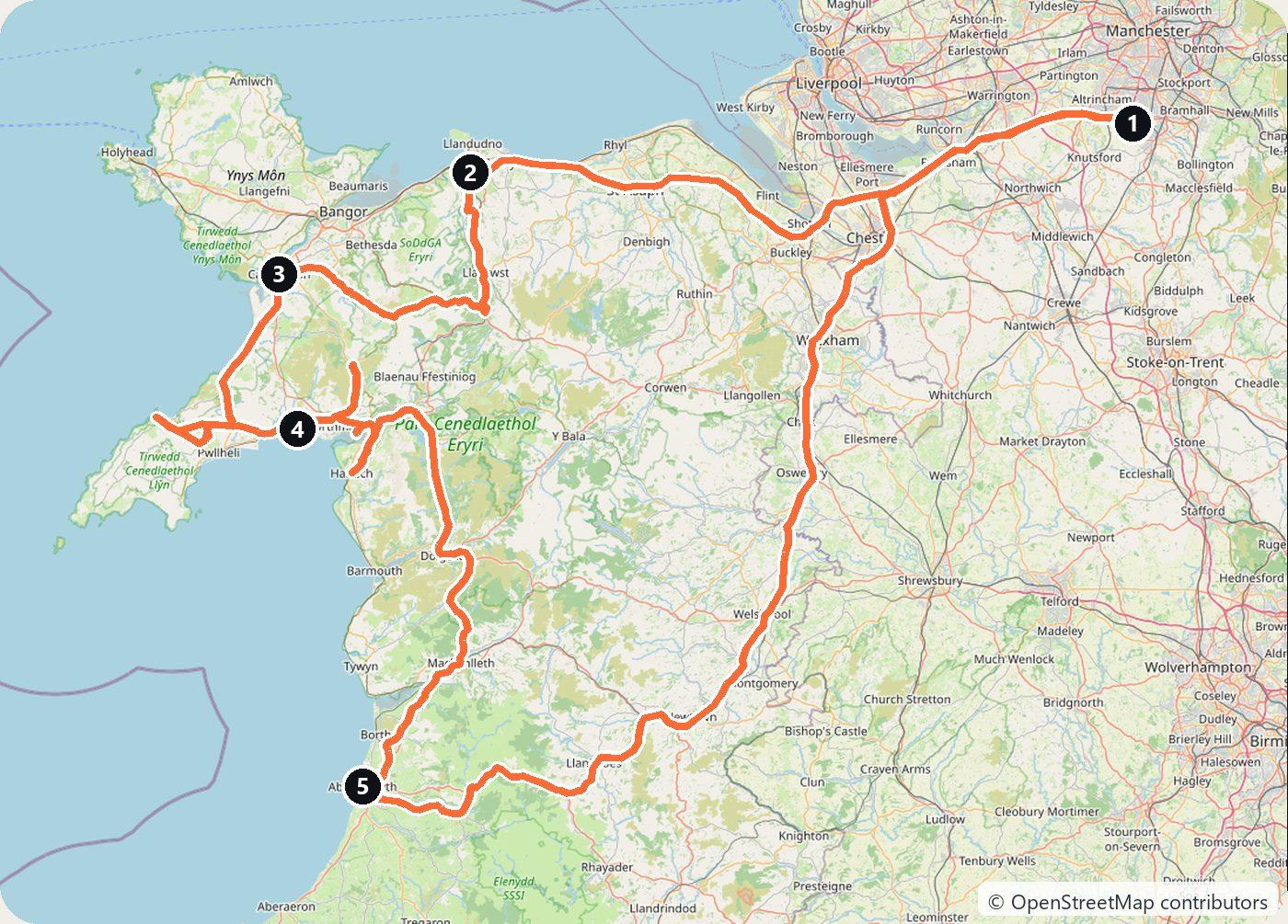
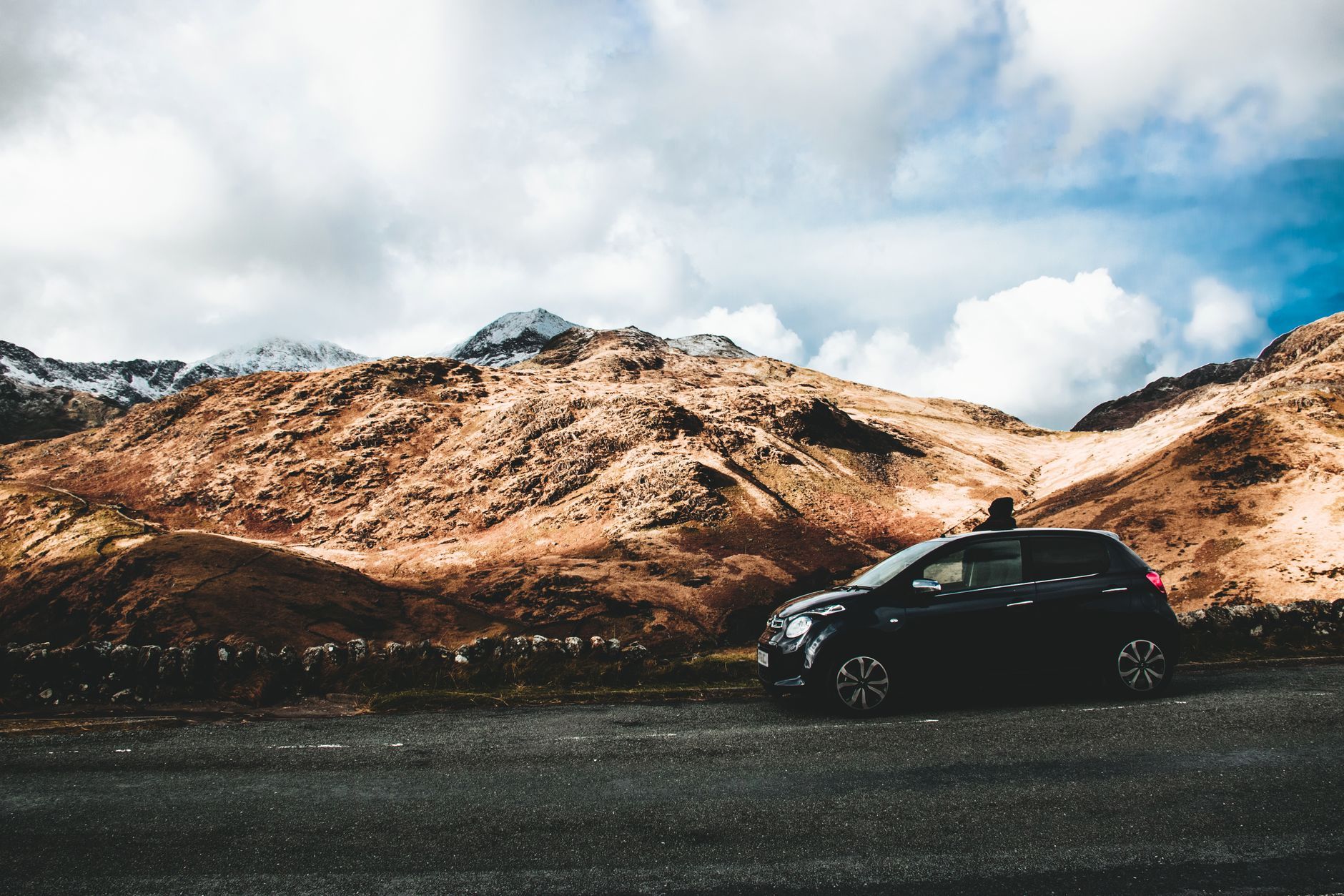
North Wales packs mountains, medieval castles and a long, quiet coast into a small area. This loop starts at Manchester Airport, follows the coast to the walled town of Conwy, climbs through Eryri (Snowdonia) over the Llanberis Pass, and runs out along the Llŷn Peninsula to Aberdaron. It then turns south past Beddgelert, Portmeirion and Harlech to Aberystwyth, and comes back to Manchester through mid Wales. It makes about 627 km in five days.
Britain drives on the left. There is no vignette and no toll anywhere on this loop. In Wales the default speed limit in towns and villages has been 20 mph since September 2023; some roads have since gone back to 30 mph, so follow the signs. Eryri became the first national park in Wales in 1951, and the castles of Conwy, Caernarfon and Harlech on this route, with the walls of Conwy and Caernarfon, are part of the UNESCO World Heritage Site of the Castles and Town Walls of King Edward in Gwynedd, listed in 1986.
Day 1 — Manchester to Conwy (118 km)
Pick up the car at Manchester Airport and take the M56 and the A55 along the north coast of Wales to Conwy, about an hour and a half away. Edward I’s architect, Master James of St George, built the castle and the town walls between 1283 and 1287. The walls still run in an unbroken ring of about 1.3 km around the old town, and you can walk along much of the top; a short section is closed for repairs until Easter 2027. The castle is open all year except 24–26 December and 1 January. Sleep in Conwy.
Day 2 — Betws-y-Coed and the Llanberis Pass to Caernarfon (64 km)
Drive south up the Conwy valley to Betws-y-Coed, a village of grey stone where the rivers Llugwy and Lledr meet the Conwy. Thomas Telford’s cast-iron Waterloo Bridge carries the old London–Holyhead road over the river. Just west of the village, Swallow Falls (Rhaeadr Ewynnol) tumbles down the Llugwy; you pay a small fee at a turnstile.
Continue through Capel Curig and over the Llanberis Pass on the A4086. At the top, Pen-y-Pass is the start of the most popular paths up Yr Wyddfa (Snowdon), but until 1 November 2026 its small car park must be booked in advance, from £25. Without a booking, drive on down the pass.
In Llanberis, the Snowdon Mountain Railway, opened in 1896, climbs about 7.6 km towards the summit of Yr Wyddfa, at 1,085 m the highest mountain in Wales. Trains run from spring until about the start of November; early and late in the season they stop at Clogwyn, about three-quarters of the way up, and reach the summit only in the main season, so book ahead and check which station your date serves. Across the lake rise the terraces of the old Dinorwig slate quarry, part of the Slate Landscape of Northwest Wales, a UNESCO World Heritage Site since 2021. The National Slate Museum in the old quarry workshops closed in November 2024 for a large redevelopment; check whether it has reopened.
End the day in Caernarfon, whose castle was begun in 1283. In 1969 Prince Charles was invested as Prince of Wales inside its walls. Sleep in Caernarfon.
Day 3 — The Llŷn Peninsula to Criccieth (93 km)
Drive south-west onto the Llŷn Peninsula. At Morfa Nefyn, leave the car in the paid National Trust car park: cars cannot drive down to Porthdinllaen, a row of houses on the beach. Walk there in about 20 minutes across the golf course, or along the sand at low tide, to the Tŷ Coch Inn at the water’s edge; check its opening days before you go.
Continue to Aberdaron, near the tip of the peninsula. For centuries it was the last stop for pilgrims on their way to Bardsey Island, and the church of St Hywyn stands right above the beach. Boats to Bardsey leave from nearby Porth Meudwy only in good weather and must be booked. Drive back east along the south coast to Criccieth, where a castle of the Welsh princes stands on a headland between two beaches. It opens only on some days of the week, with timed tickets, so check before you go. Sleep in Criccieth.
Day 4 — Beddgelert, Portmeirion and Harlech to Aberystwyth (138 km)
Drive through Porthmadog and north on the A498 through the Aberglaslyn Pass to Beddgelert, a stone village where the rivers Colwyn and Glaslyn meet. A riverside walk of about 1.6 km leads to Gelert’s Grave, the stone of the legendary hound of Prince Llywelyn; the grave itself is usually credited to a local innkeeper of the late 18th century.
Go back south to Portmeirion, the Italian-style village that the architect Clough Williams-Ellis built on the Dwyryd estuary between 1925 and 1975. The TV series The Prisoner was filmed here in 1966 and 1967. You pay to enter; the village is closed to day visitors only on 25 and 26 December.
Cross the estuary on the toll-free Pont Briwet to Harlech. Its castle, built for Edward I in the 1280s, stands on a rock high above the dunes; the sea once came up to its foot, and the Way from the Sea, a stair of 108 steps, let ships supply it during a siege. Follow the coast to Barmouth, at the mouth of the Mawddach, which a long timber railway viaduct from 1867 crosses, with a footway beside the line. Then drive inland through Dolgellau and Machynlleth to Aberystwyth, where the Cliff Railway, open since 1896, climbs Constitution Hill above the seafront. Sleep in Aberystwyth.
Day 5 — Devil’s Bridge back to Manchester (214 km)
Drive east into the hills to Devil’s Bridge, where three bridges are built one on top of the other over the gorge of the Mynach; the lowest is medieval. Paths with steep, slippery steps lead down past the Mynach Falls (paid entry). Then cross mid Wales through Llanidloes, Newtown and Welshpool, and continue by Wrexham and Chester back to Manchester Airport, about three hours of driving.
Costs
Use the cost calculator to price fuel and nights for your dates. There are no tolls and no vignette on this route. Budget for accommodation, fuel for about 627 km, car rental, paid parking in the towns and at the sights, the Snowdon Mountain Railway, and entry to the castles: from September 2026 an adult ticket costs £12.90 at Conwy, £14.90 at Caernarfon and £10.40 at Harlech. Portmeirion, Swallow Falls and Devil’s Bridge charge entry too. Parking at Pen-y-Pass costs from £25 and must be booked; otherwise use the Sherpa’r Wyddfa bus from Llanberis.
This trip is also in the free Roadcut trip planner: change the number of days and where you sleep each night, pick your vehicle to see the fuel cost, check the weather on the road, and open each day in Google Maps, Apple Maps or Waze.
Where to stay on this route
Night by night, in the towns this itinerary sleeps in.
- Night 1Hotels in Conwy →
- Night 2Hotels in Caernarfon →
- Night 3Hotels in Criccieth →
- Night 4Hotels in Aberystwyth →
The search opens with sample dates a month from today — change them to yours on Booking. Affiliate link — we may earn a commission at no extra cost to you.
The route on video
Get this itinerary by email
The days and the nights in your inbox, with a link back here when you are ready to book.
We use your address only to send this itinerary, unless you tick the box. Privacy
⚡ By electric car on this route
56 charging stations within 1.5 km of the road.
For most of them OpenStreetMap does not record the power, so we cannot say where the fast chargers are — check your charging app before you set off.
According to OpenStreetMap and operators’ websites. Fast = a DC plug or 50 kW and more; not every station has its power filled in, so there may be more. See them on the planner map → · EV charging →
🚦 Know before you go
Vignette · Tolls · Bridges & tunnels · Good to know
Vignette. The UK has no vignette, so this loop needs none.
Tolls. No tolls anywhere on this loop. The M56, the A55 along the North Wales coast and all the Welsh roads used here are free.
Bridges & tunnels. Between Portmeirion and Harlech the road crosses the Dwyryd estuary on Pont Briwet, rebuilt in 2015 and free to cross. The Barmouth viaduct over the Mawddach carries only the railway and a footway, so drive round by Dolgellau.
Good to know. Britain drives on the left, and in Wales the default limit in towns and villages is 20 mph. Until 1 November 2026 the car park at Pen-y-Pass must be booked in advance, from £25; otherwise park in Llanberis and take the Sherpa'r Wyddfa bus. Cars cannot drive down to Porthdinllaen: use the paid National Trust car park in Morfa Nefyn and walk.
Estimate your exact costs in the cost calculator. Prices are approximate — check official sites before you travel. Some links are affiliate links.
Plan this trip
Where to sleep
Hotels & B&Bs →Holiday homes & apartments →Campsites (bookable) →Campervan & overnight spots →Tours & tickets
Find things to do →Affiliate link — we may earn a commission at no extra cost to you.
Drive on from here
New road trips in your inbox
One email when we publish a new European route — the full guide, map and real costs. No spam, unsubscribe anytime.